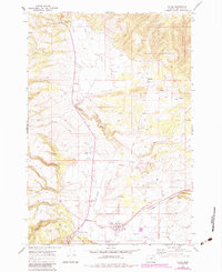
1967 Map of Ukiah
USGS Topo · Published 1984About this map
Ukiah and Albee anchor this mid-1960s survey of Umatilla County, where the southern boundary of the Umatilla National Forest meets a landscape defined by deep canyons and high plateaus. The settlement at Ukiah is established near the confluence of Camas Creek and Wilkins Creek, serving as a gateway to the wooded uplands. Transport patterns of the era are visible through a network of specialized routes, including the Steer Trail and a remote Landing Strip located north of town. The map also highlights early conservation and recreation efforts along the highway corridors, marked by the Battle Mtn Forest Wayside and the Ukiah-Dale Forest Wayside. Water resources are central to the geography here, with Owens Creek, Snipe Creek, and Pine Creek carving through the terrain, while several isolated springs and a Well indicate the importance of water management in this high-altitude environment.
Find a feature on this map
30 named features on this map. Tap any name to fly to it.
Don’t see what you’re looking for? This feature index may not catch every label — zoom into the map to look around manually.
Map Details
Editions of this 1967 Ukiah Map
2 editions found
Other maps of this area

1953 · Pendleton
USGS Topo · 1:250,000

1956 · Pendleton
USGS Topo · 1:250,000

1967 · Ukiah SE
USGS Topo · 1:24,000

1967 · Granite Meadows
USGS Topo · 1:24,000

1967 · Bridge Creek
USGS Topo · 1:24,000

1967 · Carney Butte
USGS Topo · 1:24,000

1967 · Ukiah
USGS Topo · 1:24,000

1967 · Owens Butte
USGS Topo · 1:24,000

1968 · Gurdane
USGS Topo · 1:24,000

1969 · Sugarbowl Creek
USGS Topo · 1:24,000