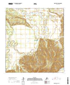
2017 Map of Unalakleet A-1 SW
USGS Topo · Published 2017About this map
The Innoko National Wildlife Refuge dominates this sub-arctic terrain, encompassing a vast network of wetlands and riverine lowlands in the Yukon-Koyukuk region. The landscape is defined by the winding course of Sucker Creek, which meanders through the central and western sections of the quadrangle before eventually feeding the broader basin. In the southeastern corner, the Innoko River makes a brief appearance, carving through the alluvial flats. This 2017 survey illustrates the complex hydrology of the interior, where numerous unnamed lakes and seasonal ponds dot the drainage between the primary watercourses. The absence of roads or permanent settlements highlights the wilderness character of this protected area, focusing instead on the precise topographical relief and natural boundaries of the public land survey system.
Find a feature on this map
10 named features on this map. Tap any name to fly to it.
Don’t see what you’re looking for? This feature index may not catch every label — zoom into the map to look around manually.
Map Details
Editions of this 2017 Unalakleet A-1 SW Map
This is the sole edition of this map. No revisions or reprints were ever made.
Other maps of this area

1951 · Unalakleet
USGS Topo · 1:250,000

1951 · Holy Cross
USGS Topo · 1:250,000

1952 · Unalakleet A-2
USGS Topo · 1:63,360

1952 · Unalakleet A-1
USGS Topo · 1:63,360

1952 · Holy Cross D-2
USGS Topo · 1:63,360

1952 · Holy Cross D-1
USGS Topo · 1:63,360

1952 · Unalakleet
USGS Topo · 1:250,000

1952 · Holy Cross
USGS Topo · 1:250,000

1964 · Unalakleet
USGS Topo · 1:250,000
2017 · Unalakleet A-1 NW
USGS Topo · 1:25,000