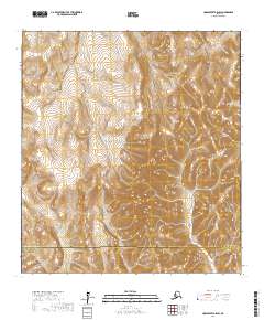
2017 Map of Unalakleet A-5 SW
USGS Topo · Published 2017About this map
The Golsovia River and its tributaries carve through the expansive Nulato Hills in this western Alaska survey. The landscape is defined by its drainage systems, including the headwaters and runs of Jackson Cr and Otter Cr, which illustrate the complex hydrology of the region. This area serves as a significant jurisdictional boundary, clearly marking the transition between the Nome Census Area and the Kusilvak Census Area.
Find a feature on this map
12 named features on this map. Tap any name to fly to it.
Don’t see what you’re looking for? This feature index may not catch every label — zoom into the map to look around manually.
Map Details
Editions of this 2017 Unalakleet A-5 SW Map
This is the sole edition of this map. No revisions or reprints were ever made.
Other maps of this area

1951 · Unalakleet
USGS Topo · 1:250,000

1951 · Holy Cross
USGS Topo · 1:250,000

1952 · Unalakleet A-5
USGS Topo · 1:63,360

1952 · Holy Cross D-5
USGS Topo · 1:63,360

1952 · Unalakleet A-6
USGS Topo · 1:63,360
1952 · Holy Cross D-6
USGS Topo · 1:63,360

1952 · Unalakleet
USGS Topo · 1:250,000

1952 · Holy Cross
USGS Topo · 1:250,000

1964 · Unalakleet
USGS Topo · 1:250,000
2017 · Holy Cross D-6 NE
USGS Topo · 1:25,000