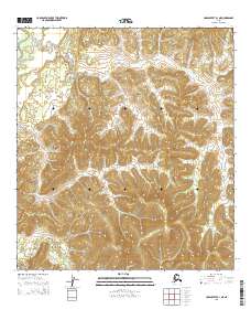
2015 Map of Unalakleet B-1 NE
USGS Topo · Published 2015About this map
Papa Willie Creek meanders through the northern reaches of this interior landscape, marking a remote drainage system in the Yukon-Koyukuk region. The terrain is defined by the high, undulating ridges of the Nulato Hills, where the elevation changes underscore the isolation of the western Alaskan wilderness. To the south, Shovel Cr cuts through the southwestern corner, illustrating the intricate hydrography of the Unalakleet River watershed. This survey outlines the section lines for Townships 23 and 24 South, Ranges 2 and 3 West, showing how the Public Land Survey System imposes a grid over a land devoid of permanent settlements or modern road infrastructure.
Find a feature on this map
6 named features on this map. Tap any name to fly to it.
Don’t see what you’re looking for? This feature index may not catch every label — zoom into the map to look around manually.
Map Details
Editions of this 2015 Unalakleet B-1 NE Map
This is the sole edition of this map. No revisions or reprints were ever made.
Other maps of this area

1951 · Ophir
USGS Topo · 1:250,000

1951 · Unalakleet
USGS Topo · 1:250,000

1952 · Unalakleet C-1
USGS Topo · 1:63,360

1952 · Unalakleet B-1
USGS Topo · 1:63,360

1952 · Unalakleet
USGS Topo · 1:250,000

1954 · Ophir C-6
USGS Topo · 1:63,360
1954 · Ophir B-6
USGS Topo · 1:63,360

1954 · Ophir
USGS Topo · 1:250,000

1964 · Unalakleet
USGS Topo · 1:250,000
2014 · Ophir B-6 SW
USGS Topo · 1:25,000