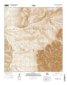
2015 Map of Unalakleet B-3 NE
USGS Topo · Published 2015About this map
McDonald Cr defines the drainage patterns of this high-elevation Alaskan landscape within the Yukon-Koyukuk region. The terrain is characterized by dramatic topographic relief, rising from valley bottoms toward significant peaks in the eastern and southern sectors of the quadrangle. As a modern survey, it meticulously documents the boundaries of the Public Land Survey System, including the intersection of t23s r7w, t23s r8w, t24s r7w, and t24s r8w. These grid designations are essential for understanding land management and ownership in a region largely devoid of permanent human settlements or infrastructure. The absence of roads or structures highlights the wilderness character of the interior, where the primary geographical markers are the natural contours of the land and the winding path of McDonald Cr.
Find a feature on this map
5 named features on this map. Tap any name to fly to it.
Don’t see what you’re looking for? This feature index may not catch every label — zoom into the map to look around manually.
Map Details
Editions of this 2015 Unalakleet B-3 NE Map
This is the sole edition of this map. No revisions or reprints were ever made.
Other maps of this area

1951 · Unalakleet
USGS Topo · 1:250,000

1952 · Unalakleet C-2
USGS Topo · 1:63,360

1952 · Unalakleet C-3
USGS Topo · 1:63,360

1952 · Unalakleet B-3
USGS Topo · 1:63,360

1952 · Unalakleet B-2
USGS Topo · 1:63,360

1952 · Unalakleet
USGS Topo · 1:250,000

1964 · Unalakleet
USGS Topo · 1:250,000
2015 · Unalakleet B-3 NW
USGS Topo · 1:25,000
2015 · Unalakleet C-2 SW
USGS Topo · 1:25,000
2015 · Unalakleet B-2 NW
USGS Topo · 1:25,000