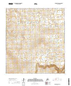
2017 Map of Unalakleet B-5 SW
USGS Topo · Published 2017About this map
The Klikitarik River and Golsonia River define the drainage patterns of this Alaskan landscape within the Nome Census Area. This part of the Unalakleet region is characterized by a high concentration of small lakes and ponds scattered across the lowlands between undulating terrain. The hydrology reveals a complex network of seasonal water bodies and narrow channels typical of the subarctic tundra. Surveyed by the U.S. Geological Survey, the map emphasizes the natural topographical transitions without the presence of permanent settlements or developed road networks, reflecting the primary role of river systems as the principal geographical markers in this remote territory.
Find a feature on this map
9 named features on this map. Tap any name to fly to it.
Don’t see what you’re looking for? This feature index may not catch every label — zoom into the map to look around manually.
Map Details
Editions of this 2017 Unalakleet B-5 SW Map
This is the sole edition of this map. No revisions or reprints were ever made.
Other maps of this area

1951 · Unalakleet
USGS Topo · 1:250,000

1952 · Unalakleet A-5
USGS Topo · 1:63,360

1952 · Unalakleet B-6
USGS Topo · 1:63,360

1952 · Unalakleet B-5
USGS Topo · 1:63,360

1952 · Unalakleet A-6
USGS Topo · 1:63,360

1952 · Unalakleet
USGS Topo · 1:250,000

1964 · Unalakleet
USGS Topo · 1:250,000
2017 · Unalakleet B-5 NE
USGS Topo · 1:25,000
2017 · Unalakleet A-6 NE
USGS Topo · 1:25,000
2017 · Unalakleet B-5 NW
USGS Topo · 1:25,000