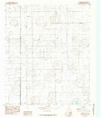
1985 Map of Underwood
USGS Topo · Published 1985About this map
Underwood and Alley represent small, dispersed settlements on the Texas High Plains during the mid-1980s. This landscape in Hale County is characterized by a remarkable density of oil or water infrastructure, with numerous Well sites punctuating the terrain across the entire quadrangle. The natural topography is defined by the subtle, winding course of Crawfish Draw, which provides the primary drainage through an otherwise flat agricultural and industrial expanse. This 1985 provisional map also identifies a location marked Holmes, reflecting the area's history of rural homesteads and localized surveying units that have defined this portion of the Panhandle.
Find a feature on this map
5 named features on this map. Tap any name to fly to it.
Don’t see what you’re looking for? This feature index may not catch every label — zoom into the map to look around manually.
Map Details
Editions of this 1985 Underwood Map
This is the sole edition of this map. No revisions or reprints were ever made.
Other maps of this area

1954 · Lubbock
USGS Topo · 1:250,000

1954 · Plainview
USGS Topo · 1:250,000

1957 · Abernathy
USGS Topo · 1:62,500

1958 · Plainview
USGS Topo · 1:250,000

1965 · Heckville
USGS Topo · 1:24,000

1968 · Happy Union
USGS Topo · 1:24,000

1968 · Julia Lake
USGS Topo · 1:24,000
1968 · Hale Center SW
USGS Topo · 1:24,000
1968 · Hale Center
USGS Topo · 1:24,000
1976 · Abernathy SE
USGS Topo · 1:24,000