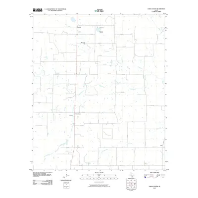
2010 Map of Union Center
USGS Topo · Published 2010About this map
Romney and Mountain Top stand at the northern edge of this West Texas landscape, where the rural character is defined by a dense network of county roads and seasonal watercourses. The drainage of the Sabana River and its tributaries, including Yellow Branch and Long Branch, shapes the local geography. Small, unincorporated communities like Union Center, Branton, and Okra are dispersed throughout the region, reflecting a decentralized agricultural settlement pattern. The presence of an Oil Gas Lease in the southern portion of the sheet points to the regional significance of mineral extraction alongside traditional ranching. For those researching local history, the Elm Cemetery near Elm Creek provides a specific point of reference for genealogical study in this corner of Eastland County.
Find a feature on this map
49 named features on this map. Tap any name to fly to it.
Don’t see what you’re looking for? This feature index may not catch every label — zoom into the map to look around manually.
Map Details
Editions of this 2010 Union Center Map
This is the sole edition of this map. No revisions or reprints were ever made.
Other maps of this area

1894 · Eastland
USGS Topo · 1:125,000

1931 · Baird
USGS Topo · 1:125,000

1932 · Baird
USGS Topo · 1:125,000

1954 · Abilene
USGS Topo · 1:250,000

1958 · Abilene
USGS Topo · 1:250,000

1966 · Sipe Springs
USGS Topo · 1:24,000
1966 · Rising Star
USGS Topo · 1:24,000

1966 · Carbon
USGS Topo · 1:24,000

1966 · Scranton
USGS Topo · 1:24,000

1966 · Cisco South
USGS Topo · 1:24,000