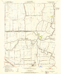
1952 Map of Union Island
USGS Topo · Published 1953About this map
Union Island is defined by an intricate network of waterways and reclaimed agricultural land in the San Joaquin Delta of the early 1950s. The landscape is a testament to hydraulic engineering, featuring the Fabian and Bell Canal and Grant Line Canal alongside natural meandering channels like Salmon Slough and Tom Payne Slough. The land grant history remains visible through the El Pescadero (Pico and Naglee) boundary, which bisects the southern half of the sheet. Industrial and civic infrastructure is concentrated near the Southern Pacific railroad line, including a Sugar Refinery and several rural educational sites such as the David Bixler Sch and Naglee School. The map captures the area just as groundwater extraction and gas exploration were shaping the local economy, evidenced by scattered pumps and Gas Wells.
Find a feature on this map
36 named features on this map. Tap any name to fly to it.
Don’t see what you’re looking for? This feature index may not catch every label — zoom into the map to look around manually.
Map Details
Editions of this 1952 Union Island Map
4 editions found
Other maps of this area

1907 · Tesla
USGS Topo · 1:62,500

1913 · Woodward Island
USGS Topo · 1:31,680

1913 · Stockton
USGS Topo · 1:31,680

1913 · Holt
USGS Topo · 1:31,680

1914 · Bethany
USGS Topo · 1:31,680

1914 · Union Island
USGS Topo · 1:31,680

1915 · Vernalis
USGS Topo · 1:31,680

1915 · Lathrop
USGS Topo · 1:31,680

1916 · Byron
USGS Topo · 1:62,500

1916 · Tracy
USGS Topo · 1:31,680