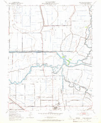
1952 Map of Union Island
USGS Topo · Published 1966About this map
The delta landscapes of Union Island and the Stewart Tract are defined by a complex web of natural sloughs and engineered waterways in the mid-20th century. This survey reveals how the land was organized by the historic El Pescadero (Pico and Naglee) Grant Line, where the reclaimed delta soils supported intensive agriculture and early industrial development. Near the southern edge of the quadrangle, the industrial footprint is marked by the Sugar Refinery and a Sewage Disposal plant, both adjacent to the Southern Pacific railroad line. Local education and community life are anchored by rural schoolhouses such as the David Bixler Sch, Naglee School, and North School. The map captures the delicate balance between the flow of the Old River and the Fabian and Bell Canal, essential for managing the water levels of this fertile San Joaquin County region.
Find a feature on this map
33 named features on this map. Tap any name to fly to it.
Don’t see what you’re looking for? This feature index may not catch every label — zoom into the map to look around manually.
Map Details
Editions of this 1952 Union Island Map
4 editions found
Other maps of this area

1907 · Tesla
USGS Topo · 1:62,500

1913 · Woodward Island
USGS Topo · 1:31,680

1913 · Stockton
USGS Topo · 1:31,680

1913 · Holt
USGS Topo · 1:31,680

1914 · Bethany
USGS Topo · 1:31,680

1914 · Union Island
USGS Topo · 1:31,680

1915 · Vernalis
USGS Topo · 1:31,680

1915 · Lathrop
USGS Topo · 1:31,680

1916 · Byron
USGS Topo · 1:62,500

1916 · Tracy
USGS Topo · 1:31,680