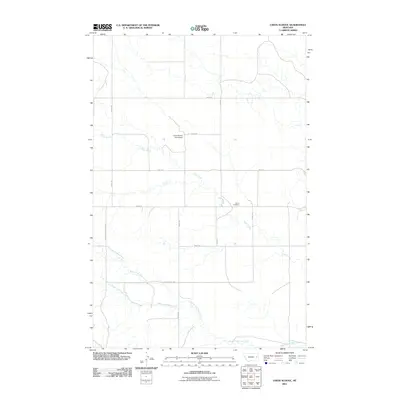
2011 Map of Union School
USGS Topo · Published 2011About this map
Union School (Historical) marks the site of an earlier educational center in this sparsely populated stretch of Prairie County, Montana. The landscape is defined by the winding paths of Clear Creek and its major tributaries, including the South Fork Clear Creek and Upper Fork Clear Creek, which carve drainage patterns through the terrain. Evidence of the local community's endurance is found at the Union Cemetery, situated near the confluence of local routes like Road 224. A network of rural section-line roads, such as Road 205 and Fas 467, provides the primary framework for movement between ranching properties. This digital-era survey preserves the memory of rural social hubs that have since faded into history, offering a detailed map of the modern and historical landmarks of this eastern Montana prairie.
Find a feature on this map
15 named features on this map. Tap any name to fly to it.
Don’t see what you’re looking for? This feature index may not catch every label — zoom into the map to look around manually.
Map Details
Editions of this 2011 Union School Map
This is the sole edition of this map. No revisions or reprints were ever made.
Other maps of this area

1954 · Glendive
USGS Topo · 1:250,000

1957 · Glendive
USGS Topo · 1:250,000

1958 · Glendive
USGS Topo · 1:250,000
1982 · Circle
USGS Topo · 1:100,000
1983 · Union School
USGS Topo · 1:24,000
1983 · Lindsay SW
USGS Topo · 1:24,000
1983 · North Coulee
USGS Topo · 1:24,000
1983 · Olson Coulee South
USGS Topo · 1:24,000
1983 · Mount Antelope
USGS Topo · 1:24,000
1983 · Deer Creek Church
USGS Topo · 1:24,000