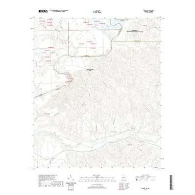
2020 Map of Union
USGS Topo · Published 2020About this map
The Chattahoochee River carves a winding path along the state line between Alabama and Georgia, defining the western edge of Stewart County. This 2020 landscape is characterized by the confluence of numerous tributaries, including Hannahatchee Creek, Hichitee Cr, and Ihagee Cr, which drain the undulating terrain into the main river channel. Settlement in the area is anchored by the community of Union, with several family-named landmarks such as Upper Bradley Place and Heard Place providing specific genealogical reference points. Numerous small burial grounds are scattered throughout the region, including Cottonton Cem, Irena Cem, Mathis Cem, and Fitzgerald Cem, often situated near rural junctions like Union Pleasant Grove. The map also details a network of secondary roads such as Omaha Union Rd and Mount Zion Church Rd that connect these remote homesites and timberlands.
Find a feature on this map
42 named features on this map. Tap any name to fly to it.
Don’t see what you’re looking for? This feature index may not catch every label — zoom into the map to look around manually.
Map Details
Editions of this 2020 Union Map
This is the sole edition of this map. No revisions or reprints were ever made.
Other maps of this area

1908 · Columbus
USGS Topo · 1:62,500

1914 · Seale
USGS Topo · 1:62,500

1929 · Columbus
USGS Topo · 1:48,000

1947 · Columbus
USGS Topo · 1:62,500

1949 · Fort Mitchell
USGS Topo · 1:24,000

1949 · Julia
USGS Topo · 1:24,000

1949 · Cusseta
USGS Topo · 1:24,000

1950 · Fort Benning
USGS Topo · 1:24,000

1950 · Louvale
USGS Topo · 1:24,000

1950 · Lumpkin
USGS Topo · 1:24,000