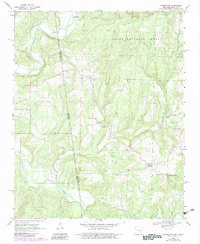
1969 Map of Uniontown
USGS Topo · Published 1983About this map
Uniontown sits at the heart of this Crawford County landscape, where the foothills of the Ozark National Forest meet the historic border between Arkansas and Oklahoma. The map clearly delineates the Old Indian Treaty Boundary, a significant geopolitical line that cuts north-to-south, separating the Ozark hills from what was once Indian Territory. This border is mirrored by the winding course of Lee Creek to the west, which carves deep valleys through the terrain. For genealogists, the survey identifies several family and community landmarks, including Salem Cem, Allyson Cem, and Spears Cem. The rural social fabric is further traced through small spiritual centers like New Home Ch and Dripping Springs Ch, while industrial activity is noted at a local Quarry near Dripping Springs.
Find a feature on this map
23 named features on this map. Tap any name to fly to it.
Don’t see what you’re looking for? This feature index may not catch every label — zoom into the map to look around manually.
Map Details
Editions of this 1969 Uniontown Map
3 editions found
Other maps of this area

1879 · Fort Smith
USGS Topo · 1:62,500

1887 · Van Buren
USGS Topo · 1:62,500

1890 · Fort Smith
USGS Topo · 1:125,000

1898 · Winslow #3
USGS Topo · 1:62,500

1898 · Tahlequah
USGS Topo · 1:125,000

1898 · Winslow
USGS Topo · 1:125,000

1900 · Sallisaw
USGS Topo · 1:125,000

1901 · Winslow
USGS Topo · 1:125,000

1901 · Tahlequah
USGS Topo · 1:125,000

1905 · Tahlequah
USGS Topo · 1:125,000