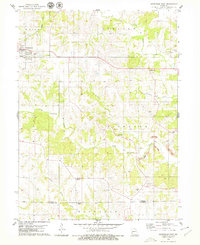
1979 Map of Unionville East
USGS Topo · Published 1979About this map
Unionville serves as the primary hub on this northern Missouri landscape, situated near the headwaters of numerous creeks that drain southward toward the Putnam Co Sullivan Co line. The terrain is defined by the winding paths of North Blackbird Creek and South Blackbird Creek, which carve through the townships of Union, Lincoln, and Richland. This 1970s survey reveals a rural economy transitioning from traditional farming toward heavy industry, evidenced by extensive Strip Mine operations that follow the drainage of Richland Creek. Local genealogy is well-preserved through numerous family and community landmarks, including Christian Home Ch and a high density of rural burial grounds like Anders Cem and Pherigo Cem. Small settlements such as Rosewood and leisure features like the Country Club reflect the social fabric of the county during this era.
Find a feature on this map
30 named features on this map. Tap any name to fly to it.
Don’t see what you’re looking for? This feature index may not catch every label — zoom into the map to look around manually.
Map Details
Editions of this 1979 Unionville East Map
This is the sole edition of this map. No revisions or reprints were ever made.
Other maps of this area

1912 · Green City
USGS Topo · 1:62,500

1914 · Green City
USGS Topo · 1:62,500

1939 · Centerville
USGS Topo · 1:62,500

1941 · Centerville
USGS Topo · 1:62,500

1942 · Seymour
USGS Topo · 1:62,500

1944 · Seymour
USGS Topo · 1:62,500

1954 · Centerville
USGS Topo · 1:250,000

1957 · Centerville
USGS Topo · 1:250,000

1958 · Centerville
USGS Topo · 1:250,000

1964 · Unionville West
USGS Topo · 1:24,000