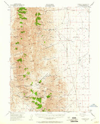
1954 Map of Unionville
USGS Topo · Published 1960About this map
The Humboldt Range dominates this mid-century Nevada landscape, revealing a dense network of mining operations that once fueled the regional economy. The historic settlement of Unionville serves as a central hub, situated near the Buena Vista Creek drainage. To the south, the intense industrial activity around Rochester Mines and Nenzel Crown Point Mines is evident, with numerous claims like the Buck and Charley Mine and Octopus Mine dotting the slopes of Nenzel Hill.
Find a feature on this map
90 named features on this map. Tap any name to fly to it.
Don’t see what you’re looking for? This feature index may not catch every label — zoom into the map to look around manually.
Map Details
Editions of this 1954 Unionville Map
3 editions found
Other maps of this area

1931 · Lovelock
USGS Topo · 1:250,000

1932 · Sonoma Range
USGS Topo · 1:250,000

1935 · Lovelock
USGS Topo · 1:250,000

1939 · Sonoma Range
USGS Topo · 1:250,000

1954 · Unionville
USGS Topo · 1:62,500

1954 · Buffalo Mtn
USGS Topo · 1:62,500

1955 · Lovelock
USGS Topo · 1:250,000

1955 · Winnemucca
USGS Topo · 1:250,000

1956 · Oreana
USGS Topo · 1:62,500

1956 · Imlay
USGS Topo · 1:62,500