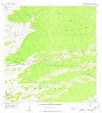
1956 Map of Upper Piihonua
USGS Topo · Published 1976About this map
Volcanic activity and high-elevation watersheds define this mid-century landscape on the slopes of Mauna Kea and Mauna Loa. The terrain is a chronological record of eruptions, clearly delineating the Lava Flow of 1855, Lava Flow of 1881, and the more recent Lava Flow of 1942. These historical events cut across the Hilo Forest Reserve and the Upper Waiakea Forest Reserve, creating a complex patchwork of vegetation and raw volcanic stone.
Find a feature on this map
25 named features on this map. Tap any name to fly to it.
Don’t see what you’re looking for? This feature index may not catch every label — zoom into the map to look around manually.
Map Details
Editions of this 1956 Upper Piihonua Map
2 editions found
Other maps of this area

1915 · Honomu
USGS Topo · 1:62,500

1917 · Hilo
USGS Topo · 1:62,500

1930 · Humuula
USGS Topo · 1:62,500

1932 · Hilo
USGS Topo · 1:62,500

1954 · Hawaii North
USGS Topo · 1:250,000

1956 · Puu Oo
USGS Topo · 1:24,000

1956 · Pua Akala
USGS Topo · 1:24,000

1956 · Upper Piihonua
USGS Topo · 1:24,000
1956 · Puu Ulaula
USGS Topo · 1:24,000
1956 · Kulani
USGS Topo · 1:24,000