
1963 Map of Upstead Lake
USGS Topo · Published 1964About this map
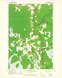
The Duluth Missabe and Iron Range railroad cuts a sharp diagonal through the heart of this Saint Louis County landscape, anchoring the small settlements of Hull and Toivola Station during the early 1960s. This interior region is defined by extensive wetlands, notably the Toivola Swamp and Lavell Swamp, which separate the primary rail corridor from isolated water bodies like Upstead Lake and Fenberg Lake. A secondary Railroad Grade in the west suggests the legacy of earlier logging or industrial transport through the Cedar Valley. In the southwest corner, the Floodwood River snakes through the terrain near the junction of several town and range boundaries, while small tributaries like Sand Creek drain the eastern reaches of the quadrangle.
Find a feature on this map
17 named features on this map. Tap any name to fly to it.
Don’t see what you’re looking for? This feature index may not catch every label — zoom into the map to look around manually.
Map Details
Editions of this 1963 Upstead Lake Map
This is the sole edition of this map. No revisions or reprints were ever made.
Other maps of this area

1952 · Riley
USGS Topo · 1:24,000

1952 · Silica
USGS Topo · 1:24,000

1952 · Little Swan
USGS Topo · 1:24,000

1954 · Hibbing
USGS Topo · 1:250,000

1957 · Hibbing
USGS Topo · 1:250,000

1958 · Hibbing
USGS Topo · 1:250,000

1963 · Elmer
USGS Topo · 1:24,000

1963 · Toivola SW
USGS Topo · 1:24,000
1963 · Toivola
USGS Topo · 1:24,000

1964 · Hibbing
USGS Topo · 1:250,000