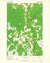
1963 Map of Toivola
USGS Topo · Published 1964About this map
The St Louis River meanders through the heart of this Iron Range landscape, carving a serpentine path through the extensive Toivola Swamp. This 1963 survey documents the intersection of heavy industry and the isolated wetlands of St. Louis County, where the Duluth Missabe and Iron Range railroad cuts a straight line across the boggy terrain. The settlement of Toivola serves as a small hub of activity, supported by the nearby Toivola Station and marked by the Lookout Tower standing watch over the timber and peatlands.
Find a feature on this map
16 named features on this map. Tap any name to fly to it.
Don’t see what you’re looking for? This feature index may not catch every label — zoom into the map to look around manually.
Map Details
Editions of this 1963 Toivola Map
This is the sole edition of this map. No revisions or reprints were ever made.
Other maps of this area

1951 · Casco
USGS Topo · 1:24,000

1952 · Riley
USGS Topo · 1:24,000

1952 · Little Swan
USGS Topo · 1:24,000

1954 · Hibbing
USGS Topo · 1:250,000

1957 · Hibbing
USGS Topo · 1:250,000

1958 · Hibbing
USGS Topo · 1:250,000

1963 · Elmer
USGS Topo · 1:24,000

1963 · Toivola SW
USGS Topo · 1:24,000

1963 · Upstead Lake
USGS Topo · 1:24,000

1963 · Meadowlands NW
USGS Topo · 1:24,000