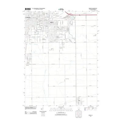
2012 Map of Urbana
USGS Topo · Published 2012About this map
The University of Illinois campus and the surrounding residential grids of Urbana and Champaign dominate the northern landscape of this 2012 survey. This academic and agricultural hub is reflected in the specialized infrastructure present, including the University of Illinois Dairy Cattle Research Unit and Illinois Field. The map reveals the clear transition from the dense urban street plan to the expansive prairie farmsteads and drainage networks further south, where the terrain is marked by Yankee Ridge. Several historic burying grounds, such as Mount Hope Cem and Roselawn Cem, are positioned near the campus, providing a clear reference for local genealogists. Beyond the city limits, the landscape is defined by the headwaters of the Embarras River and the small settlements of Mira and Philo, where the agricultural heritage of the county remains the primary driver of land use and development.
Find a feature on this map
140 named features on this map. Tap any name to fly to it.
Don’t see what you’re looking for? This feature index may not catch every label — zoom into the map to look around manually.
Map Details
Editions of this 2012 Urbana Map
This is the sole edition of this map. No revisions or reprints were ever made.
Other maps of this area

1906 · Urbana
USGS Topo · 1:62,500

1907 · Mahomet
USGS Topo · 1:62,500

1950 · Tuscola
USGS Topo · 1:62,500

1956 · Villa Grove
USGS Topo · 1:62,500

1957 · Urbana
USGS Topo · 1:62,500

1957 · Urbana
USGS Topo · 1:24,000

1957 · Rising
USGS Topo · 1:24,000

1957 · Mahomet
USGS Topo · 1:62,500

1957 · Bondville
USGS Topo · 1:24,000
1957 · Thomasboro
USGS Topo · 1:24,000