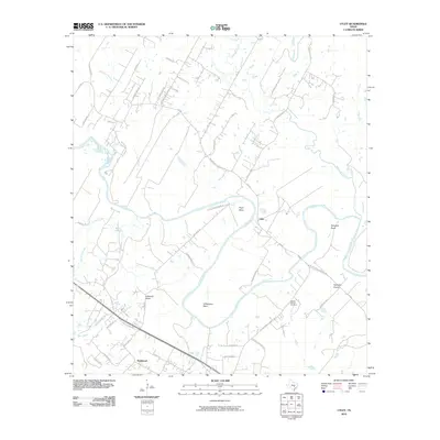
2010 Map of Utley
USGS Topo · Published 2010About this map
The Colorado River carves a winding path through this central Texas landscape, creating dramatic meanders known as Pope Bend, Wilbargers Bend, and Hemphill Bend. The terrain transitions from the low-lying Hemphill Prairie to the local high point at Caldwell Knob, illustrating the flood-plain topography typical of the region. This 2010 survey documents the settlement patterns of Utley and Wyldwood, where residential growth is increasingly visible along historical routes like the Old Bastrop Hwy. For those researching local family history, the Walker-Watson Cemetery remains a key landmark north of the river. The map also traces various tributaries, including Wilbarger Creek and Greens Creek, which define the drainage patterns before they join the main river channel.
Find a feature on this map
47 named features on this map. Tap any name to fly to it.
Don’t see what you’re looking for? This feature index may not catch every label — zoom into the map to look around manually.
Map Details
Editions of this 2010 Utley Map
This is the sole edition of this map. No revisions or reprints were ever made.
Other maps of this area

1885 · Bastrop
USGS Topo · 1:125,000

1893 · Bastrop
USGS Topo · 1:125,000

1896 · Austin
USGS Topo · 1:125,000

1897 · Austin
USGS Topo · 1:125,000

1904 · Bastrop
USGS Topo · 1:125,000

1910 · Austin
USGS Topo · 1:125,000

1948 · Elgin
USGS Topo · 1:62,500

1948 · Bastrop
USGS Topo · 1:62,500

1950 · Bastrop
USGS Topo · 1:62,500

1950 · Elgin
USGS Topo · 1:62,500