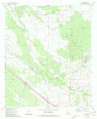
1981 Map of Vail
USGS Topo · Published 1981About this map
Vail sits at the heart of this high-desert landscape in the early 1980s, where the transport corridor of the Southern Pacific railroad meets the winding path of Pantano Wash. The map reveals a transition from traditional desert ranching at Rocking K Ranch and La Posta Quemada Ranch to the burgeoning leisure and recreation areas of Colossal Cave County Park and Rancho Del Lago. This era captures the region's spiritual and community markers, such as the Santa Rita Shrine, alongside industrial traces like the Old Railroad Grade and several gravel pits. To the east, the terrain rises toward Pistol Hill and the winding Posta Quemada Canyon, while the complex drainage systems of Cienega Creek and Aqua Verde Creek illustrate the natural hydrology that shaped local settlement patterns and infrastructure development near Irene.
Find a feature on this map
39 named features on this map. Tap any name to fly to it.
Don’t see what you’re looking for? This feature index may not catch every label — zoom into the map to look around manually.
Map Details
Editions of this 1981 Vail Map
2 editions found
Other maps of this area

1904 · Patagonia
USGS Topo · 1:125,000

1904 · Tucson
USGS Topo · 1:125,000

1905 · Patagonia
USGS Topo · 1:125,000

1905 · Tucson
USGS Topo · 1:125,000

1926 · Helvetia
USGS Topo · 1:62,500

1948 · Tucson
USGS Topo · 1:62,500

1956 · Nogales
USGS Topo · 1:250,000

1956 · Tucson
USGS Topo · 1:250,000

1957 · Tucson East
USGS Topo · 1:24,000

1957 · Tucson
USGS Topo · 1:62,500