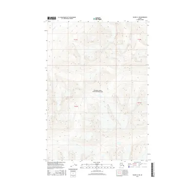
2016 Map of Valdez A-1 NE
USGS Topo · Published 2016About this map
The Tebay River winds through the northwestern corner of this high-elevation Alaskan wilderness, a terrain defined by dramatic topographic relief and extensive glacial features. This remote landscape is protected as part of Wrangell-Saint Elias National Park, where contour lines indicate sharp ridgelines and deep basins within the Unorganized Borough. Unlike more developed regions, this map shows a pure wilderness devoid of roads or permanent structures, highlighting the raw physical geography of the Copper River region. The surveying of the Public Land Survey System boundaries, including t7s r7e, t7s r8e, t8s r7e, and t8s r8e, provides a formal grid over this immense natural preserve, offering a precise reference for those navigating or studying the park's interior.
Find a feature on this map
6 named features on this map. Tap any name to fly to it.
Don’t see what you’re looking for? This feature index may not catch every label — zoom into the map to look around manually.
Map Details
Editions of this 2016 Valdez A-1 NE Map
This is the sole edition of this map. No revisions or reprints were ever made.
Other maps of this area

1950 · McCarthy A-8
USGS Topo · 1:63,360

1951 · McCarthy
USGS Topo · 1:250,000

1951 · Valdez B-1
USGS Topo · 1:63,360

1951 · Valdez A-1
USGS Topo · 1:63,360

1951 · McCarthy B-8
USGS Topo · 1:63,360

1952 · Valdez
USGS Topo · 1:250,000

1960 · McCarthy
USGS Topo · 1:250,000

1960 · Valdez
USGS Topo · 1:250,000

1995 · McCarthy B-8
USGS Topo · 1:63,360
1995 · Valdez B-1
USGS Topo · 1:63,360