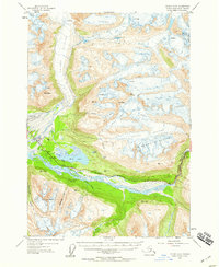
1952 Map of Valdez A-6
USGS Topo · Published 1959About this map
The Richardson Highway snakes through the glacial valleys of the Chugach Mountains, providing a vital land link in the early 1950s. This survey illustrates the proximity of aviation and traditional transport, with the Valdez Airport and a Seaplane Landing positioned near the mouth of the Valdez Glacier. The settlement pattern is sparse and utilitarian, marked by scattered Cabins and Camp 13 along the roadway.
Find a feature on this map
37 named features on this map. Tap any name to fly to it.
Don’t see what you’re looking for? This feature index may not catch every label — zoom into the map to look around manually.
Map Details
Editions of this 1952 Valdez A-6 Map
2 editions found

Other maps of this area

1948 · Cordova
USGS Topo · 1:250,000

1950 · Cordova D-7
USGS Topo · 1:63,360

1950 · Cordova D-5
USGS Topo · 1:63,360

1951 · Cordova
USGS Topo · 1:250,000

1951 · Valdez B-5
USGS Topo · 1:63,360

1951 · Cordova D-6
USGS Topo · 1:63,360

1951 · Valdez B-6
USGS Topo · 1:63,360

1951 · Valdez A-6
USGS Topo · 1:63,360

1952 · Valdez
USGS Topo · 1:250,000

1952 · Cordova D-7
USGS Topo · 1:63,360