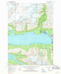
1960 Map of Valdez A-7
USGS Topo · Published 1971About this map
Valdez and its surrounding glacial landscape are captured here just before the 1964 earthquake altered the region's geography forever. This survey documents the original coastal configuration of Port Valdez, showing Old Valdez situated on its waterfront long before the town was relocated. The area’s industrial heritage is evident in the cluster of hard-rock mines along Mineral Creek and the Lowe River drainage, including the Midas Mine and Glacier Mine. North of the townsite, the massive Shoup Glacier feeds into Shoup Bay, while to the south, the Chugach National Forest spans the mountainous terrain toward Jack Bay. Historic military and aviation footprints are visible at the Fort Liscum (Site) and the Valdez Airport, marking the town’s role as a vital transportation and logistics hub for the Alaskan interior during the mid-20th century.
Find a feature on this map
49 named features on this map. Tap any name to fly to it.
Don’t see what you’re looking for? This feature index may not catch every label — zoom into the map to look around manually.
Map Details
Editions of this 1960 Valdez A-7 Map
3 editions found

Other maps of this area

1948 · Cordova
USGS Topo · 1:250,000

1950 · Cordova D-7
USGS Topo · 1:63,360

1951 · Cordova
USGS Topo · 1:250,000

1951 · Cordova D-8
USGS Topo · 1:63,360

1951 · Cordova D-6
USGS Topo · 1:63,360

1951 · Valdez B-6
USGS Topo · 1:63,360

1951 · Valdez A-6
USGS Topo · 1:63,360

1952 · Valdez
USGS Topo · 1:250,000

1952 · Cordova D-8
USGS Topo · 1:63,360

1952 · Cordova D-7
USGS Topo · 1:63,360