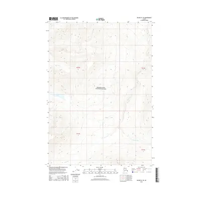
2016 Map of Valdez B-1 SE
USGS Topo · Published 2016About this map
Wrangell-Saint Elias National Park encompasses the majority of this Alaskan wilderness, where high-altitude terrain is defined by a complex drainage network. The Tebay River is the primary waterway, carving a course across the southern and eastern portions of the landscape before its confluence with the Hanagita River in the southeast. This survey captures a region largely devoid of human infrastructure, focusing instead on the glacial and fluvial systems that shape the Unorganized Borough. High-elevation features like Summit Lake and Bridge Cr feed into these larger river systems, illustrating the hydrological patterns of the interior. The map provides precise documentation of the township and range boundaries, including t6s r7e, t6s r8e, t7s r7e, and t7s r8e, which assist in locating specific wilderness tracts within the national park system.
Find a feature on this map
9 named features on this map. Tap any name to fly to it.
Don’t see what you’re looking for? This feature index may not catch every label — zoom into the map to look around manually.
Map Details
Editions of this 2016 Valdez B-1 SE Map
This is the sole edition of this map. No revisions or reprints were ever made.
Other maps of this area

1950 · McCarthy A-8
USGS Topo · 1:63,360

1951 · McCarthy
USGS Topo · 1:250,000

1951 · Valdez B-1
USGS Topo · 1:63,360

1951 · Valdez A-1
USGS Topo · 1:63,360

1951 · McCarthy B-8
USGS Topo · 1:63,360

1952 · Valdez
USGS Topo · 1:250,000

1960 · McCarthy
USGS Topo · 1:250,000

1960 · Valdez
USGS Topo · 1:250,000

1995 · McCarthy B-8
USGS Topo · 1:63,360
1995 · Valdez B-1
USGS Topo · 1:63,360