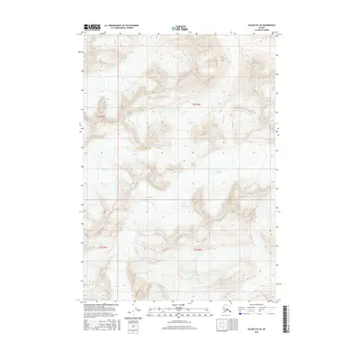
2016 Map of Valdez B-6 SE
USGS Topo · Published 2016About this map
Valdez Glacier dominates the western portion of this high-altitude landscape in the Chugach Mountains, where massive ice fields shape the drainage patterns of the Alaskan interior. This 2016 survey highlights the intricate relationship between moving ice and the surrounding terrain, capturing the extensive reach of the Tonsina Glacier and the Tsina Glacier. The map provides a precise record of the glacial extent and topographic contours across several townships, including t6s r5w, t6s r4w, t7s r5w, and t7s r4w. In a region where permanent settlements are absent, the labels focus entirely on these prominent natural features, reflecting the scale of the ice and the steep, glaciated valleys that define the geography near the Port Valdez area.
Find a feature on this map
7 named features on this map. Tap any name to fly to it.
Don’t see what you’re looking for? This feature index may not catch every label — zoom into the map to look around manually.
Map Details
Editions of this 2016 Valdez B-6 SE Map
This is the sole edition of this map. No revisions or reprints were ever made.
Other maps of this area

1951 · Valdez B-5
USGS Topo · 1:63,360

1951 · Valdez B-6
USGS Topo · 1:63,360

1951 · Valdez A-6
USGS Topo · 1:63,360

1952 · Valdez
USGS Topo · 1:250,000

1952 · Valdez A-6
USGS Topo · 1:63,360

1953 · Valdez B-6
USGS Topo · 1:63,360

1953 · Valdez A-5
USGS Topo · 1:63,360

1960 · Valdez
USGS Topo · 1:250,000
1983 · Valdez A-6 NW
USGS Topo · 1:25,000
1993 · Valdez B-6
USGS Topo · 1:63,360