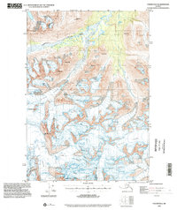
1993 Map of Valdez B-6
USGS Topo · Published 2002About this map
Glacial systems and high peaks define this interior Alaskan landscape, which remains largely untouched by roads or permanent settlements. The northern portion of the map is dominated by the Klutina River valley and its tributary, Stephens Creek, situated between massifs like Garrett Pk and Black Mtn. The terrain is characterized by massive ice fields and moving ice, notably the Klutina Glacier and the Valdez Glacier, which feed the local drainage systems. These glaciers are mapped with high detail, showing extensive Crevasses across their surfaces. High-altitude summits including Mt Ourand, Mt Evans, and Mt Schrader rise sharply from the glacial valleys. The presence of Abercrombie Mtn in the south and the Tonsina Glacier to the east illustrates the interconnected nature of the Chugach Mountains' ice sheets and the physical barriers they presented to early travelers in the region.
Find a feature on this map
16 named features on this map. Tap any name to fly to it.
Don’t see what you’re looking for? This feature index may not catch every label — zoom into the map to look around manually.
Map Details
Editions of this 1993 Valdez B-6 Map
This is the sole edition of this map. No revisions or reprints were ever made.
Other maps of this area

1950 · Valdez C-6
USGS Topo · 1:63,360

1951 · Valdez B-5
USGS Topo · 1:63,360

1951 · Valdez C-5
USGS Topo · 1:63,360

1951 · Valdez B-6
USGS Topo · 1:63,360

1951 · Valdez A-6
USGS Topo · 1:63,360

1952 · Valdez
USGS Topo · 1:250,000

1952 · Valdez A-6
USGS Topo · 1:63,360

1953 · Valdez C-6
USGS Topo · 1:63,360

1953 · Valdez C-5
USGS Topo · 1:63,360

1953 · Valdez B-6
USGS Topo · 1:63,360