
1953 Map of Valdez C-5
USGS Topo · Published 1954About this map
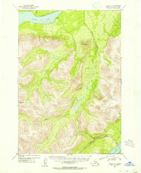
Klutina Lake dominates the northern reaches of this mid-century Alaskan wilderness, where the Mahllo River and Grayling Creek carve through the high elevations between Mt Simpson and Bence Mtn. This map captures a landscape defined by its glacial hydrology and lack of permanent infrastructure, documented just as aerial photography began to provide precise topographic detail for the Third Judicial Division. A solitary Cabin and a single Trail along the northern shore of the lake are the only markers of human presence in a territory otherwise shaped by the Tonsina Creek drainage and the remote waters of Twin Lake and Tonsina Lake. For the local historian or outdoorsman, these contours reveal the exact drainage patterns and high-altitude landmarks of the Copper River basin before modern development reached the interior.
Find a feature on this map
11 named features on this map. Tap any name to fly to it.
Don’t see what you’re looking for? This feature index may not catch every label — zoom into the map to look around manually.
Map Details
Editions of this 1953 Valdez C-5 Map
2 editions found
Other maps of this area

1948 · Valdez D-5
USGS Topo · 1:63,360

1949 · Valdez D-4
USGS Topo · 1:63,360

1949 · Valdez D-6
USGS Topo · 1:63,360

1950 · Valdez C-6
USGS Topo · 1:63,360

1951 · Valdez D-5
USGS Topo · 1:63,360

1951 · Valdez D-6
USGS Topo · 1:63,360

1951 · Valdez B-5
USGS Topo · 1:63,360

1951 · Valdez C-4
USGS Topo · 1:63,360

1951 · Valdez B-4
USGS Topo · 1:63,360

1951 · Valdez C-5
USGS Topo · 1:63,360