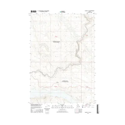
2016 Map of Valdez C-1 SW
USGS Topo · Published 2016About this map
The Chitina River flows through the southern portion of this interior Alaskan landscape, marking a significant hydrological boundary within the Wrangell-Saint Elias National Park. To the north, the terrain transitions into the Wrangell-Saint Elias National Preserve, a vast protected area defined by its dramatic relief and glacial drainage patterns. The Kotsina River winds through the central valley, joined by smaller tributaries like Iron Cr and Lorraine Cr as they descend from the high elevations surrounding Chitina. This survey illustrates the intricate network of watercourses and topographical contours that dictate movement and land use within the Copper River basin, offering a detailed record of the wilderness as it was managed and mapped in the early twenty-first century.
Find a feature on this map
11 named features on this map. Tap any name to fly to it.
Don’t see what you’re looking for? This feature index may not catch every label — zoom into the map to look around manually.
Map Details
Editions of this 2016 Valdez C-1 SW Map
This is the sole edition of this map. No revisions or reprints were ever made.
Other maps of this area

1951 · Valdez B-2
USGS Topo · 1:63,360

1951 · Valdez B-1
USGS Topo · 1:63,360

1951 · Valdez C-2
USGS Topo · 1:63,360

1951 · Valdez C-1
USGS Topo · 1:63,360

1952 · Valdez
USGS Topo · 1:250,000

1953 · Valdez C-2
USGS Topo · 1:63,360

1953 · Valdez C-1
USGS Topo · 1:63,360

1960 · Valdez
USGS Topo · 1:250,000
1995 · Valdez B-1
USGS Topo · 1:63,360

1996 · Valdez C-2
USGS Topo · 1:63,360