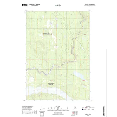
2019 Map of Valdez C-1 SW
USGS Topo · Published 2019About this map
Wrangell-St. Elias National Park and the adjacent Wrangell-St. Elias National Preserve dominate this Alaskan landscape, where the confluence of major glacial river systems defines the geography. The map traces the broad, braided path of the Chitina River as it flows westward through the southern portion of the quadrangle. Further north, the Kotsina River cuts through the terrain, joined by smaller tributaries like Iron Cr and Loraine Cr. This area is characterized by significant topographic relief and the relative absence of permanent human settlement, save for the vital transportation artery of the Edgerton Hwy / McCarthy Rd. This road provides a narrow corridor of accessibility through the protected wilderness, following the natural contours of the river valleys to connect the region's interior with the outside world.
Find a feature on this map
11 named features on this map. Tap any name to fly to it.
Don’t see what you’re looking for? This feature index may not catch every label — zoom into the map to look around manually.
Map Details
Editions of this 2019 Valdez C-1 SW Map
This is the sole edition of this map. No revisions or reprints were ever made.
Other maps of this area

1951 · Valdez B-2
USGS Topo · 1:63,360

1951 · Valdez B-1
USGS Topo · 1:63,360

1951 · Valdez C-2
USGS Topo · 1:63,360

1951 · Valdez C-1
USGS Topo · 1:63,360

1952 · Valdez
USGS Topo · 1:250,000

1953 · Valdez C-2
USGS Topo · 1:63,360

1953 · Valdez C-1
USGS Topo · 1:63,360

1960 · Valdez
USGS Topo · 1:250,000
1995 · Valdez B-1
USGS Topo · 1:63,360

1996 · Valdez C-2
USGS Topo · 1:63,360