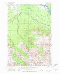
1951 Map of Valdez C-3
USGS Topo · Published 1972About this map
The Tonsina River carves a dramatic path through this high-elevation Alaskan landscape, joined by tributaries such as Dust Creek and Bernard Creek. Settlement in the early 1950s is concentrated in the north along the Edgerton Highway, where the community of Kenney Lake sits near a small Cemetery. This area represents a period of post-war northern expansion and infrastructure development, with the highway serving as a vital link between the interior and the coast. To the east, the massive Copper River forms a natural boundary, while the southern portion of the map is dominated by high peaks and the Kimball Pass. The map detail shows a transition from the river-bottom lands of Willow Creek to the steep, glaciated terrain of the Chugach foothills, illustrating the logistical challenges faced by early road builders and settlers in the Copper River basin.
Find a feature on this map
9 named features on this map. Tap any name to fly to it.
Don’t see what you’re looking for? This feature index may not catch every label — zoom into the map to look around manually.
Map Details
Editions of this 1951 Valdez C-3 Map
3 editions found
Other maps of this area

1949 · Valdez D-4
USGS Topo · 1:63,360

1951 · Valdez B-2
USGS Topo · 1:63,360

1951 · Valdez B-3
USGS Topo · 1:63,360

1951 · Valdez C-2
USGS Topo · 1:63,360

1951 · Valdez C-3
USGS Topo · 1:63,360

1951 · Valdez C-4
USGS Topo · 1:63,360

1951 · Valdez B-4
USGS Topo · 1:63,360

1952 · Valdez
USGS Topo · 1:250,000

1952 · Valdez D-4
USGS Topo · 1:63,360

1953 · Valdez C-2
USGS Topo · 1:63,360