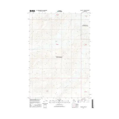
2016 Map of Valdez D-1 NW
USGS Topo · Published 2016About this map
Chetaslina Glacier and Chichokna Glacier define the high-altitude landscape of this 2016 survey, where ice and meltwater shape the terrain. This region marks the transition between strictly protected wilderness and multi-use lands, as the boundary for Wrangell-Saint Elias National Park meets the Wrangell-Saint Elias National Preserve. The hydrology of the area is centered on the drainage systems of the Chetaslina River and its major tributary, the E Fork Chetaslina River. These glacial-fed waterways demonstrate the dynamic geomorphology of the Copper River basin, carving through complex elevation contours as they flow southwest. The map provides a detailed view of these natural boundaries and the vast, unpopulated terrain typical of the interior Alaskan wilderness.
Find a feature on this map
12 named features on this map. Tap any name to fly to it.
Don’t see what you’re looking for? This feature index may not catch every label — zoom into the map to look around manually.
Map Details
Editions of this 2016 Valdez D-1 NW Map
This is the sole edition of this map. No revisions or reprints were ever made.
Other maps of this area

1951 · Gulkana
USGS Topo · 1:250,000

1952 · Valdez
USGS Topo · 1:250,000

1959 · Valdez D-2
USGS Topo · 1:63,360
1959 · Gulkana A-1
USGS Topo · 1:63,360

1959 · Gulkana
USGS Topo · 1:250,000

1959 · Valdez D-1
USGS Topo · 1:63,360

1960 · Valdez
USGS Topo · 1:250,000

1965 · Gulkana
USGS Topo · 1:250,000
1996 · Valdez D-1
USGS Topo · 1:63,360
1996 · Valdez D-2
USGS Topo · 1:63,360