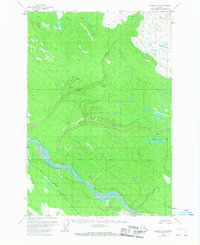
1958 Map of Valdez D-3
USGS Topo · Published 1967About this map
The Copper River dominates the southwestern portion of this Alaskan landscape, where the braided riverbed meets the foothills of the interior. In this 1958 survey, the Old Edgerton Highway serves as the primary artery for travel, winding through the lower elevations north of the river. The map details a wild, water-abundant environment where the Nadina River and Dadina River carve through unsurveyed terrain to join the main Copper River drainage. A single Cabin near the shores of Dadina Lake provides a rare marker of human habitation in this expansive wilderness. This area, largely defined by the Copper River Base Line, shows the region before more modern infrastructure changes, preserving the original routes used by early settlers and travelers along the Willow Creek and Rock Creek drainages.
Find a feature on this map
9 named features on this map. Tap any name to fly to it.
Don’t see what you’re looking for? This feature index may not catch every label — zoom into the map to look around manually.
Map Details
Editions of this 1958 Valdez D-3 Map
2 editions found

Other maps of this area

1949 · Gulkana A-3
USGS Topo · 1:63,360

1949 · Valdez D-4
USGS Topo · 1:63,360

1951 · Gulkana
USGS Topo · 1:250,000

1951 · Valdez C-2
USGS Topo · 1:63,360

1951 · Valdez C-3
USGS Topo · 1:63,360

1951 · Valdez C-4
USGS Topo · 1:63,360

1952 · Gulkana A-3
USGS Topo · 1:63,360

1952 · Valdez
USGS Topo · 1:250,000

1952 · Valdez D-4
USGS Topo · 1:63,360

1953 · Valdez C-2
USGS Topo · 1:63,360