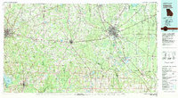
1981 Map of Valdosta
USGS Topo · Published 1981About this map
The Withlacoochee River and Ochlockonee River dominate the drainage of this South Georgia and North Florida borderland, where the regional economy was defined by the intersection of major rail lines and agriculture. In the early 1980s, the Georgia Southern and Florida and Seaboard Coast Line railroads provided the infrastructure for hubs like Valdosta, Quitman, and Thomasville. The presence of Moody Air Force Base and its Moody AFB Annex northeast of Valdosta highlights the military importance of the area, while the Grand Bay Wildlife Management Area and the vast Lake Miccosukee illustrate the natural wetlands of the coastal plain. Numerous small communities, such as Clyattville, Hahira, and Boston, are mapped alongside rural landmarks like New Hope Church and Shiloh Church, providing a clear view of the settlement patterns before modern suburban expansion transformed the outskirts of these county seats.
Find a feature on this map
127 named features on this map. Tap any name to fly to it.
Don’t see what you’re looking for? This feature index may not catch every label — zoom into the map to look around manually.
Map Details
Editions of this 1981 Valdosta Map
This is the sole edition of this map. No revisions or reprints were ever made.
Other maps of this area

1953 · Dothan
USGS Topo · 1:250,000

1953 · Waycross
USGS Topo · 1:250,000

1954 · Dothan
USGS Topo · 1:250,000

1954 · Lloyd
USGS Topo · 1:24,000

1954 · Greenville
USGS Topo · 1:24,000

1954 · Greenville NE
USGS Topo · 1:24,000

1954 · Valdosta
USGS Topo · 1:250,000

1954 · Tallahassee
USGS Topo · 1:250,000

1955 · Dothan
USGS Topo · 1:250,000

1955 · Lamont
USGS Topo · 1:24,000