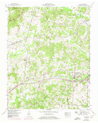
1950 Map of Vale
USGS Topo · Published 1975About this map
Pea Ridge and the Tennessee Valley Divide define the rugged topography of this Carroll County landscape during the mid-20th century. The Louisville and Nashville railroad serves as the primary industrial corridor, connecting the settlements of Hollow Rock and Bruceton in the southeast. This rail presence, combined with the Broadway of America and Browning Highway, underscores the area's role as a regional transit point between the Tennessee River and the western plains. Local life is anchored by family-named landmarks and rural institutions such as Crews Store, the Cannon Sch, and the Bethlehem Church. Genealogists will find a high density of burial sites across the ridges, including Abernathy Cem, Barren Spring Cem, and Old Union Cem. The mapping reveals a complex drainage network where the Drainage Canal and various creeks like Crooked Creek and Cherry Creek navigate the undulating terrain.
Find a feature on this map
69 named features on this map. Tap any name to fly to it.
Don’t see what you’re looking for? This feature index may not catch every label — zoom into the map to look around manually.
Map Details
Editions of this 1950 Vale Map
3 editions found

Other maps of this area

1936 · Seventeen Creek
USGS Topo · 1:24,000

1936 · Mansfield
USGS Topo · 1:24,000

1936 · Vale
USGS Topo · 1:24,000

1936 · Center Ridge
USGS Topo · 1:24,000

1936 · Bruceton
USGS Topo · 1:24,000

1936 · Buena Vista
USGS Topo · 1:24,000

1936 · Manleyville
USGS Topo · 1:24,000

1940 · Manleyville
USGS Topo · 1:24,000

1941 · Manleyville
USGS Topo · 1:24,000

1950 · Palmer Shelter
USGS Topo · 1:24,000