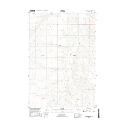
2017 Map of Vale Creek Ranch
USGS Topo · Published 2017About this map
Vale Creek Ranch sits at the heart of this landscape, where the northern plains of Montana transition into a network of drainages and coulees. The map reveals a drainage pattern dominated by Pryor Cr, which is fed by numerous tributaries including Kent Cr, Hamilton Cr, and Monument Cr. The land is segmented by early thoroughfares like Pryor Rd and Thornton Rd, tracing the routes used by local ranchers and travelers across the Yellowstone County terrain. To the east, the topography becomes more defined at Magpie Coulee and the winding course of Birdhead Cr. The arrangement of these water sources and ranch roads provides a clear picture of how water access and topography dictated the settlement and movement through this part of the Crow Indian Reservation boundary region in recent years.
Find a feature on this map
26 named features on this map. Tap any name to fly to it.
Don’t see what you’re looking for? This feature index may not catch every label — zoom into the map to look around manually.
Map Details
Editions of this 2017 Vale Creek Ranch Map
This is the sole edition of this map. No revisions or reprints were ever made.
Other maps of this area

1893 · Huntley
USGS Topo · 1:125,000

1954 · Billings
USGS Topo · 1:250,000

1956 · Yegen
USGS Topo · 1:24,000

1957 · Billings
USGS Topo · 1:250,000

1958 · Billings
USGS Topo · 1:250,000

1967 · Deep Creek
USGS Topo · 1:24,000

1967 · Pryor
USGS Topo · 1:24,000

1967 · Soda Springs NW
USGS Topo · 1:24,000

1967 · Soda Springs
USGS Topo · 1:24,000
1967 · Chilkoot Coulee
USGS Topo · 1:24,000