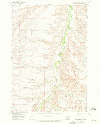
1967 Map of Vale Creek Ranch
USGS Topo · Published 1972About this map
Vale Creek Ranch serves as a central landmark in this 1967 survey of south-central Montana, where the terrain is defined by the winding course of Pryor Creek and its numerous tributaries. The northern boundary of the Crow Indian Res Bdy cuts across the northwest corner of the sheet, marking a significant division in land use and jurisdiction. The landscape is characterized by deeply incised drainages including Magpie Coulee, Kent Creek, and Monument Creek, which flow toward the greener riparian corridor along Pryor Road. This area, mapped just after the mid-1960s, reveals a pastoral ranching environment reliant on reliable water sources like Hamilton Spring. The presence of a solitary Gravel Pit near the northern edge suggests localized industry amidst the ranchlands and dry coulees that dominate the topography of Yellowstone County.
Find a feature on this map
16 named features on this map. Tap any name to fly to it.
Don’t see what you’re looking for? This feature index may not catch every label — zoom into the map to look around manually.
Map Details
Editions of this 1967 Vale Creek Ranch Map
This is the sole edition of this map. No revisions or reprints were ever made.
Other maps of this area

1893 · Huntley
USGS Topo · 1:125,000

1954 · Billings
USGS Topo · 1:250,000

1956 · Yegen
USGS Topo · 1:24,000

1957 · Billings
USGS Topo · 1:250,000

1958 · Billings
USGS Topo · 1:250,000

1967 · Deep Creek
USGS Topo · 1:24,000

1967 · Pryor
USGS Topo · 1:24,000

1967 · Soda Springs NW
USGS Topo · 1:24,000

1967 · Soda Springs
USGS Topo · 1:24,000
1967 · Chilkoot Coulee
USGS Topo · 1:24,000