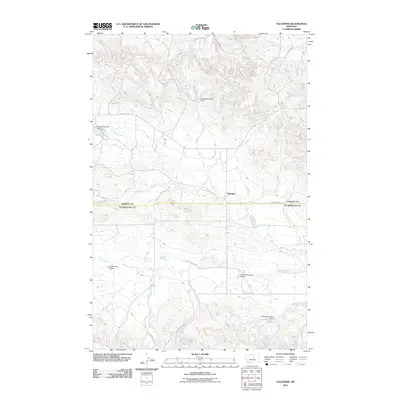
2011 Map of Valentine
USGS Topo · Published 2011About this map
Valentine serves as the central point of interest in this part of Fergus County, Montana, situated at the junction of Valentine Rd and local trails. The landscape is defined by an intricate network of drainage systems, most notably Blood Creek, which winds through the center of the quadrangle. Water management is a primary feature of this rural landscape, evidenced by several numbered reservoirs and dams named for local families. These include Sluggett Number 1 Dam and Sluggett Number 2 Dam to the north, while the southern reaches are marked by N Barnett Number 1 Dam and N Barnett Number 2 Dam. The presence of these specific family-named improvements along Sage Creek and other tributaries illustrates the enduring relationship between agricultural land use and the region's intermittent water sources during the early 21st century.
Find a feature on this map
11 named features on this map. Tap any name to fly to it.
Don’t see what you’re looking for? This feature index may not catch every label — zoom into the map to look around manually.
Map Details
Editions of this 2011 Valentine Map
This is the sole edition of this map. No revisions or reprints were ever made.
Other maps of this area

1954 · Lewistown
USGS Topo · 1:250,000

1959 · Lewistown
USGS Topo · 1:250,000

1985 · Brown Spring
USGS Topo · 1:24,000
1985 · Dovetail Butte
USGS Topo · 1:24,000

1985 · Bear Creek Reservoir SE
USGS Topo · 1:24,000

1985 · Valentine
USGS Topo · 1:24,000
1985 · Kachia Reservoir
USGS Topo · 1:24,000
1985 · Pipes Coulee
USGS Topo · 1:24,000

1986 · Wild Horse Lake
USGS Topo · 1:24,000

1986 · Dry Blood Creek West
USGS Topo · 1:24,000