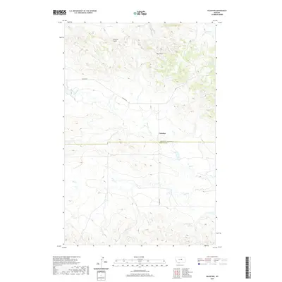
2020 Map of Valentine
USGS Topo · Published 2020About this map
Valentine sits at the intersection of local history and rural geography, positioned directly on the boundary of Fergus and Petroleum counties. This central Montana landscape is defined by its drainage systems, where the terrain is carved by the winding paths of Blood Creek and Sage Creek. The map documents a sparse, high-plains environment where water sources like Valentine Springs and seasonal drainages such as Schoneke Coulee and Hay Coulee dictated the placement of early ranching infrastructure and local roads. The prominent Valentine Road serves as the primary artery through this territory, connecting isolated points across the township lines. This survey captures the enduring spatial layout of a remote ranching community, illustrating how physical geography and county jurisdictions converge in the heart of Big Sky Country.
Find a feature on this map
17 named features on this map. Tap any name to fly to it.
Don’t see what you’re looking for? This feature index may not catch every label — zoom into the map to look around manually.
Map Details
Editions of this 2020 Valentine Map
This is the sole edition of this map. No revisions or reprints were ever made.
Other maps of this area

1954 · Lewistown
USGS Topo · 1:250,000

1959 · Lewistown
USGS Topo · 1:250,000

1985 · Brown Spring
USGS Topo · 1:24,000
1985 · Dovetail Butte
USGS Topo · 1:24,000

1985 · Bear Creek Reservoir SE
USGS Topo · 1:24,000

1985 · Valentine
USGS Topo · 1:24,000
1985 · Kachia Reservoir
USGS Topo · 1:24,000
1985 · Pipes Coulee
USGS Topo · 1:24,000

1986 · Wild Horse Lake
USGS Topo · 1:24,000

1986 · Dry Blood Creek West
USGS Topo · 1:24,000