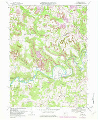
1968 Map of Valier
USGS Topo · Published 1982About this map
Mahoning Creek winds through the heart of this landscape, separating the townships of Perry and North Mahoning as it flows past the small communities of Valier, Fordham, and Sportsburg. The map reveals an area defined by its rural industry and transportation network, dominated by the winding route of the Baltimore and Ohio railroad and numerous strip mines that mark the hillsides. The influence of early 20th-century extraction is visible in the presence of a Tipple and various gas wells dotting the drainages of Nicely Run and McCracken Run.
Find a feature on this map
51 named features on this map. Tap any name to fly to it.
Don’t see what you’re looking for? This feature index may not catch every label — zoom into the map to look around manually.
Map Details
Editions of this 1968 Valier Map
4 editions found
Other maps of this area

1906 · Punxsutawney
USGS Topo · 1:62,500

1909 · Smicksburg
USGS Topo · 1:62,500

1922 · Du Bois
USGS Topo · 1:62,500

1924 · Du Bois
USGS Topo · 1:62,500

1924 · Brookville
USGS Topo · 1:62,500

1926 · Brookville
USGS Topo · 1:62,500

1938 · Smicksburg
USGS Topo · 1:62,500

1939 · Smicksburg
USGS Topo · 1:62,500

1939 · Punxsutawney
USGS Topo · 1:62,500

1942 · Punxsutawney
USGS Topo · 1:62,500
Featured Places
- Sportsburg, Young Township
- Oliver Township, PA
- West Mahoning Township, PA
- North Mahoning Township, PA
- Perry Township, PA