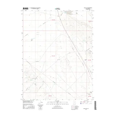
2017 Map of Valley City
USGS Topo · Published 2017About this map
Valley City occupies a central position in this arid Grand County landscape, defined by the drainage systems of Thompson Wash and Crescent Wash. The area showcases a complex history of resource extraction and transit, evidenced by the proximity of Copper Mine Ridge and several water management features like the Valley City Reservoir. To the south, the terrain transitions into the Blue Hills and the expansive Mancos Desert W, where the historic Moab to Boulder Town route traverses the desert floor. This 2017 survey details the infrastructure supporting modern aviation at Canyonlands Field while preserving names of older landmarks like Crystal Spring and the Rock Corral Reservoir. The presence of named tracks such as Dubinky Well Rd and Blue Hills Rd highlights the network of backcountry access points that cut through the canyon country and the Klondike Flat.
Find a feature on this map
33 named features on this map. Tap any name to fly to it.
Don’t see what you’re looking for? This feature index may not catch every label — zoom into the map to look around manually.
Map Details
Editions of this 2017 Valley City Map
This is the sole edition of this map. No revisions or reprints were ever made.
Other maps of this area

1885 · La Sal
USGS Topo · 1:250,000

1951 · The Knoll
USGS Topo · 1:62,500

1952 · Moab 4 NW
USGS Topo · 1:24,000

1952 · Moab 3 NE
USGS Topo · 1:24,000

1952 · Moab 3 NW
USGS Topo · 1:24,000

1956 · Moab
USGS Topo · 1:250,000

1958 · Crescent Junction
USGS Topo · 1:62,500

1958 · Thompson
USGS Topo · 1:62,500

1959 · Moab
USGS Topo · 1:250,000
1959 · Moab
USGS Topo · 1:62,500