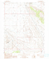
1991 Map of Valley City
USGS Topo · Published 1991About this map
Valley City (Site) sits at the northern edge of this arid landscape, a historic location defined by its reliance on the Valley City Reservoir. The map documents a territory shaped by resource extraction and water management, with numerous infrastructure markers such as Check Dams, Queens Well, and a Radio Tower scattered across the high desert. Industrial history is evident in the presence of several Prospect sites, a Quarry, and a Mine Shaft, indicating the persistent search for mineral wealth within the Salt Valley and the surrounding Blue Hills. To the south, Canyonlands Field serves as a modern aviation landmark, while natural features like Crystal Spring and the Tenmile Wash Reservoir highlight the critical role of water sources in this environment. Numerous 4wd tracks and transmission lines crisscross the terrain, reflecting the connectivity required for mining and utility operations during the early 1990s.
Find a feature on this map
25 named features on this map. Tap any name to fly to it.
Don’t see what you’re looking for? This feature index may not catch every label — zoom into the map to look around manually.
Map Details
Editions of this 1991 Valley City Map
This is the sole edition of this map. No revisions or reprints were ever made.
Other maps of this area

1885 · La Sal
USGS Topo · 1:250,000

1951 · The Knoll
USGS Topo · 1:62,500

1952 · Moab 4 NW
USGS Topo · 1:24,000

1952 · Moab 3 NE
USGS Topo · 1:24,000

1952 · Moab 3 NW
USGS Topo · 1:24,000

1956 · Moab
USGS Topo · 1:250,000

1958 · Crescent Junction
USGS Topo · 1:62,500

1958 · Thompson
USGS Topo · 1:62,500

1959 · Moab
USGS Topo · 1:250,000
1959 · Moab
USGS Topo · 1:62,500