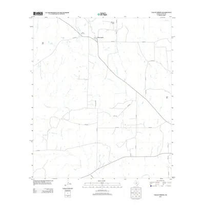
2012 Map of Valley Spring
USGS Topo · Published 2012About this map
Valley Spring and its surrounding ranchlands are defined by the winding drainages of the Llano River watershed. The settlement sits at the junction of Ranch Road 1659 and several county roads, serving as a hub for the local rural community. Notable topographic landmarks such as Deer Mtn and Wolf Mtn rise above the drainage basins of Johnson Cr and San Fernando Cr, which crisscross the territory.
Find a feature on this map
33 named features on this map. Tap any name to fly to it.
Don’t see what you’re looking for? This feature index may not catch every label — zoom into the map to look around manually.
Map Details
Editions of this 2012 Valley Spring Map
This is the sole edition of this map. No revisions or reprints were ever made.
Other maps of this area

1887 · Llano
USGS Topo · 1:125,000

1894 · Llano
USGS Topo · 1:125,000

1904 · Llano
USGS Topo · 1:125,000

1909 · Llano
USGS Topo · 1:125,000

1918 · Llano
USGS Topo · 1:125,000

1954 · Llano
USGS Topo · 1:250,000

1955 · Llano
USGS Topo · 1:250,000
1955 · Magill Mountain
USGS Topo · 1:24,000

1955 · Valley Spring
USGS Topo · 1:24,000
1955 · Llano North
USGS Topo · 1:24,000