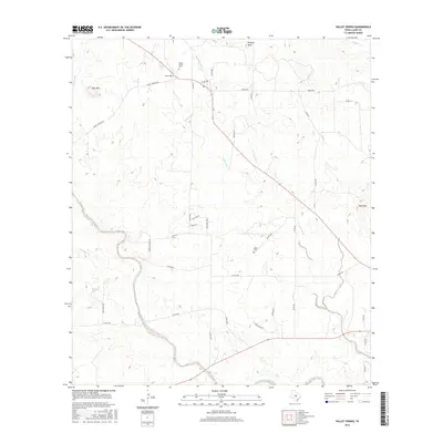
2016 Map of Valley Spring
USGS Topo · Published 2016About this map
Valley Spring and its surrounding ranchlands are depicted here in the heart of the Texas Hill Country. The settlement serves as a central hub for the area's rural road network, with routes like Valley Springs Rd and Nixon Rd connecting scattered homesteads. Significant local history is preserved at the Valley Spring Cem and the more isolated Salem Cem, providing valuable touchpoints for genealogical research. The landscape is defined by the winding course of the San Fernando Creek and its many tributaries, including Johnson Creek and Willow Creek. Prominent topographic landmarks such as Deer Mtn, Wolf Mtn, and the distinctive Phillips Rock rise above the drainage basins, illustrating the broken terrain that characterizes this portion of Llano County.
Find a feature on this map
42 named features on this map. Tap any name to fly to it.
Don’t see what you’re looking for? This feature index may not catch every label — zoom into the map to look around manually.
Map Details
Editions of this 2016 Valley Spring Map
This is the sole edition of this map. No revisions or reprints were ever made.
Other maps of this area

1887 · Llano
USGS Topo · 1:125,000

1894 · Llano
USGS Topo · 1:125,000

1904 · Llano
USGS Topo · 1:125,000

1909 · Llano
USGS Topo · 1:125,000

1918 · Llano
USGS Topo · 1:125,000

1954 · Llano
USGS Topo · 1:250,000

1955 · Llano
USGS Topo · 1:250,000
1955 · Magill Mountain
USGS Topo · 1:24,000

1955 · Valley Spring
USGS Topo · 1:24,000
1955 · Llano North
USGS Topo · 1:24,000