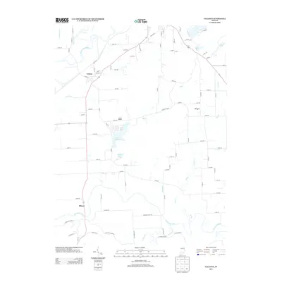
2013 Map of Vallonia
USGS Topo · Published 2013About this map
Vallonia sits at the heart of this Southern Indiana landscape, positioned between the sweeping curves of the E Fork White River to the north and the Muscatatuck River to the south. The settlement patterns here reflect a heavy reliance on the fertile bottomlands, with a dense network of county roads connecting small communities like Wegan and Millport. The area is notably characterized by its water management and recreational features, from the agricultural drainage of Wayman Ditch and Singer Ditch to the established waters of Starve Hollow Lake and Hillview Lake. At Starve Hollow, the grid of streets suggests a planned residential or recreational hub adjacent to the lake. The terrain transitions toward the east into more varied elevations, marked by Knob Lake and the drainage of Knob Cr, illustrating the typical river valley geography of Jackson County before it reaches the more broken ground of the knobs.
Find a feature on this map
78 named features on this map. Tap any name to fly to it.
Don’t see what you’re looking for? This feature index may not catch every label — zoom into the map to look around manually.
Map Details
Editions of this 2013 Vallonia Map
This is the sole edition of this map. No revisions or reprints were ever made.
Other maps of this area

1951 · Smedley
USGS Topo · 1:24,000

1953 · Kossuth
USGS Topo · 1:24,000

1956 · Vincennes
USGS Topo · 1:250,000

1956 · Louisville
USGS Topo · 1:250,000

1957 · Vincennes
USGS Topo · 1:250,000

1958 · Vincennes
USGS Topo · 1:250,000

1958 · Little York
USGS Topo · 1:24,000

1958 · Brownstown
USGS Topo · 1:24,000

1958 · Seymour
USGS Topo · 1:24,000
1959 · Vallonia
USGS Topo · 1:24,000