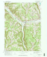
1969 Map of Van Etten
USGS Topo · Published 1971About this map
Cayuta Creek carves a deep path through the highlands of the Southern Tier, defining the industrial and transit corridor of Van Etten and Spencer. In the late 1960s, the Lehigh Valley Railroad remained a dominant fixture of the landscape, following the water level through Van Etten Junction and north past Spencer Lake. The geography is characterized by family-named ridges like Nobles Hill and Blake Hill, while the valley floors are dotted with numerous small burial grounds including Mt Hope Cem and Swartwood Cem. Beyond the villages, several Gas Wells and a prominent Pipeline south of Cooper Hill indicate the era's energy infrastructure. This document records the rural road network, including McDuffy Road and Wynkoop Road, as it connected isolated farmsteads and hilltop communities before modern expansion.
Find a feature on this map
50 named features on this map. Tap any name to fly to it.
Don’t see what you’re looking for? This feature index may not catch every label — zoom into the map to look around manually.
Map Details
Editions of this 1969 Van Etten Map
2 editions found
Other maps of this area

1893 · Ithaca
USGS Topo · 1:62,500

1895 · Ithaca
USGS Topo · 1:62,500

1900 · Dryden
USGS Topo · 1:62,500

1902 · Waverly
USGS Topo · 1:62,500

1903 · Owego
USGS Topo · 1:62,500

1905 · Watkins Glen
USGS Topo · 1:125,000

1906 · Catatonk
USGS Topo · 1:125,000

1949 · Willseyville
USGS Topo · 1:24,000

1950 · Elmira
USGS Topo · 1:250,000

1950 · Alpine
USGS Topo · 1:24,000