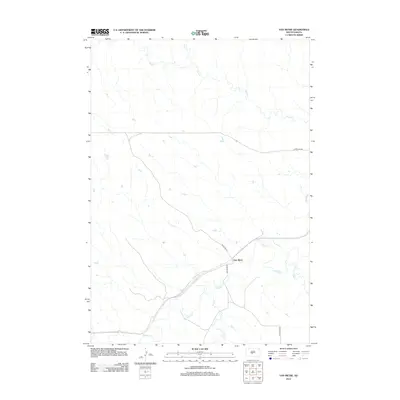
2012 Map of Van Metre
USGS Topo · Published 2012About this map
The small settlement of Van Metre sits at the heart of this Jones County landscape, positioned near the meandering course of the Bad River. This 2012 survey illustrates a sparsely populated region of South Dakota where the economy and geography are defined by the intricate network of seasonal and perennial waterways. North of the main settlement, Plum Cr and Brush Cr carve paths through the plains, while to the south, White Clay Cr and Dry Cr feed into the river valley. The infrastructure is minimal, consisting largely of unpaved access routes like Bad River Rd and Van Metre Rd, which follow the natural contours of the river basin. The map provides a clear view of the rural township's layout, showing the relationship between isolated homesteads and the vital water sources that dictate the placement of ranching and transport corridors.
Find a feature on this map
9 named features on this map. Tap any name to fly to it.
Don’t see what you’re looking for? This feature index may not catch every label — zoom into the map to look around manually.
Map Details
Editions of this 2012 Van Metre Map
This is the sole edition of this map. No revisions or reprints were ever made.
Other maps of this area

1937 · Oahe
USGS Topo · 1:62,500

1951 · Capa
USGS Topo · 1:24,000

1951 · Van Metre
USGS Topo · 1:24,000

1951 · Capa NW
USGS Topo · 1:24,000

1951 · Capa SE
USGS Topo · 1:24,000

1953 · Oahe SW
USGS Topo · 1:24,000

1953 · Wendte
USGS Topo · 1:24,000

1954 · Pierre
USGS Topo · 1:250,000

1958 · Pierre
USGS Topo · 1:250,000
1972 · Wendte SW
USGS Topo · 1:24,000