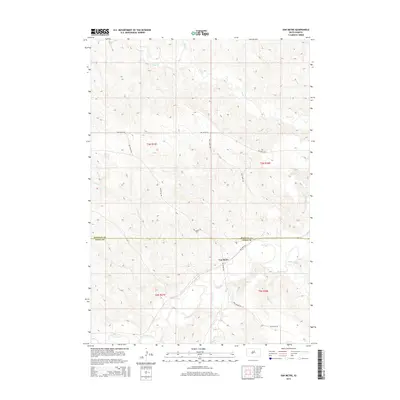
2015 Map of Van Metre
USGS Topo · Published 2015About this map
Van Metre sits at the southern edge of this West River landscape, serving as a focal point where the local road network converges near the winding path of the Bad River. The terrain is defined by a dense network of drainage systems, including Plum Cr to the north and White Clay Cr to the east, illustrating the hydraulic character of the Pierre Hills region. The map highlights the intersection of several significant local thoroughfares such as Van Metre Rd and Bull Head Rd, which traverse the county line between Stanley and Jones Counties. This cartographic record documents the persistence of small rural settlements and the established Public Land Survey System boundaries that have organized this section of South Dakota for generations.
Find a feature on this map
14 named features on this map. Tap any name to fly to it.
Don’t see what you’re looking for? This feature index may not catch every label — zoom into the map to look around manually.
Map Details
Editions of this 2015 Van Metre Map
This is the sole edition of this map. No revisions or reprints were ever made.
Other maps of this area

1937 · Oahe
USGS Topo · 1:62,500

1951 · Capa
USGS Topo · 1:24,000

1951 · Van Metre
USGS Topo · 1:24,000

1951 · Capa NW
USGS Topo · 1:24,000

1951 · Capa SE
USGS Topo · 1:24,000

1953 · Oahe SW
USGS Topo · 1:24,000

1953 · Wendte
USGS Topo · 1:24,000

1954 · Pierre
USGS Topo · 1:250,000

1958 · Pierre
USGS Topo · 1:250,000
1972 · Wendte SW
USGS Topo · 1:24,000