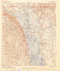
1944 Map of Vancleave
USGS Topo · Published 1944About this map
Vancleave sits along the western bluffs of the Pascagoula River, a landscape defined by the intricate winding of river channels and oxbow lakes surveyed in the early 1940s. The river bottom is a dense network of water bodies including Upper Ramsey Lake, Boggy Lake, and Dads Lake, which separated the settled uplands of Jackson County. Historic transportation relied on river crossings such as Graham Ferry and the tracks of the Mississippi Export RR running through the eastern wetlands near Harleston.
Find a feature on this map
102 named features on this map. Tap any name to fly to it.
Don’t see what you’re looking for? This feature index may not catch every label — zoom into the map to look around manually.
Map Details
Editions of this 1944 Vancleave Map
2 editions found

Other maps of this area

1921 · Grand Bay
USGS Topo · 1:62,500

1941 · Hurley
USGS Topo · 1:62,500

1941 · Vancleave
USGS Topo · 1:62,500

1941 · Lucedale
USGS Topo · 1:62,500

1942 · Wilmer
USGS Topo · 1:62,500

1943 · Pascagoula
USGS Topo · 1:62,500

1943 · Lucedale
USGS Topo · 1:62,500

1943 · Grand Bay
USGS Topo · 1:62,500

1943 · Hurley
USGS Topo · 1:62,500

1943 · Vancleave
USGS Topo · 1:62,500