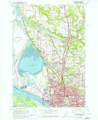
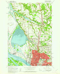
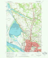
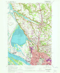
1961 Map of Vancouver
USGS Topo · Published 1971About this map
The Columbia River serves as the focal point for this survey, delineating the border between Washington and Oregon as it flows past the industrial and urban core of Vancouver. The landscape is a mix of established residential neighborhoods and significant institutional footprints, including the Fort Vancouver Nat Hist Site and the sprawling campus of Clark College. To the north, the terrain transitions into the suburban and rural reaches of Salmon Creek and Felida, where the presence of the Salmon Creek Cem and St Johns Cem offers valuable markers for those tracing local family lineages. Large water bodies like Vancouver Lake and Shillapoo Lake dominate the western portion of the map, while industrial landmarks such as the Aluminum Plant and various rail lines including the Burlington Northern reflect the mid-century economic engine of Clark County.
Find a feature on this map
71 named features on this map. Tap any name to fly to it.
Don’t see what you’re looking for? This feature index may not catch every label — zoom into the map to look around manually.
Map Details
Editions of this 1961 Vancouver Map
5 editions found

Other maps of this area

1897 · Portland
USGS Topo · 1:62,500

1905 · Portland
USGS Topo · 1:62,500

1915 · Hillsboro
USGS Topo · 1:62,500

1918 · Hillsboro
USGS Topo · 1:62,500

1922 · St. Helens
USGS Topo · 1:62,500

1940 · Hillsboro
USGS Topo · 1:62,500

1940 · Portland
USGS Topo · 1:62,500

1940 · La Center
USGS Topo · 1:62,500

1941 · St Helens
USGS Topo · 1:62,500

1943 · St Helens
USGS Topo · 1:62,500